The region offers opportunities to visit ancient villages, high passes, beautiful lakes, isolated Buddhist monasteries and also to experience the vast array of wildlife inhabiting the region, including blue sheep, mountain goat, jackal, wolf and the legendary snow leopard. The Lower and Upper Dolpo are the home of Thakuri, Brahmin subsisting on buckwheat, wheat, barley, potatoes.


Day 01. - Arrival at Kathmandu airport
Arrival at Kathmandu (1300m)
Himalayan Randonner welcomes you in Kathmandu, the capital of Nepal. We will pick you up at the airport and transfer to the hotel. The guide will introduce to the group some formalities and the activities over the next few days. One should particularly pay attention to the safety aspects of the briefing. Any questions or doubts should be asked and clarified at this time. We check your insurance details and other requirements for your trekking equipment.
Day 02. - Free day in Kathmandu
Kathmandu sightseeing:
After breakfast, we depart for sightseeing in our private vehicles, escorted by an English-speaking guide (we can provide any language speaking guide on request) to give a full taste of our vivid culture image and the enchanting manners of people. We make a tour in Monkeys' temple Swayambhunath, Pashupatinath and Durbar square in Kathmandu:
Durbar Square: This complex was palaces, courtyards and temples, built between 12th and 18th centuries, the seat of the ancient kings Malla from Kathmandu. An intriguing piece was a 17th century's stone inscription set into the wall of the palace, written in 15 languages. The Durbar square is protected by UNESCO as a world Heritage. This is the social religious and urban focal point of the city. There are museums inside the palace. You have to pay an entrance fee of Rs.250 per foreign visitor.
Swayambhunath is 6.5 kilometers west of Kathmandu from Thamel, it is situated on a hill top, Swayambhu is 2500 years old. The Stupa is a world’s most glorious Buddhist shrine and surrounded by several small pagodas. The main temple is capped by a pinnacle of copper gilt and is painted on the four sides with all seeing eyes of Lord Buddha.
Pashupatinath is dedicated to Lord Shiva, this is an holiest and most famous Brahman Nepalese temple. It is situated 5 kilometers northeast of Kathmandu on the bank of the sacred Bagmati River. It is an impressive pagoda style structure with gilt roof and richly carved by silver doors. It has bathing and cremation ghats, which are of absorbing interest to the tourists, particularly in the morning and on festival days.
Day 03. - Kathmandu Nepalgunj
Kathmandu-Nepalganj:
Our staff goes by bus from Kathmandu to Nepalganj. The group and guide will fly from Kathmandu to Nepalganj, in southwest part of the Terai, right on the border to India. Then check-in in your hotel. All what Nepalganj offers is just wandering around in the bazaar, which has everything on sale that one could imagine. You will see people from every part of Nepal, people from Tibet and India, their trade.
Day 04. - Nepalgunj to Juphal & trek to Dunai
Nepalganj to Juphal & trek to Dunai:
We fly from Nepalgunj to Juphal, and trek to Dunai. We have to go to the airport on early morning, to catch the flight to Juphal. Dolpo flights are always early in the morning, because of the high winds in the Thulo Bheri Valley which begin at around 10 am, making later flights impossible. Once you have got all your equipment out of the Twin otter in Juphal (2500m), you start out on the short walk from Juphal to Dunai. You walk downhill through meadows and past a few houses to the small hotels at Kala Gaura (2090m). From here you follow the river trail upstream to Dunai. We camp near Dunai and explore this bustling little hill town for the rest of the afternoon.
Day 05. - Dunai to Chepka
Dunai to Chepka:
Trek from Dunai to Chepka 6-7 hours, 770m ascent. You start trekking from Dunai, cross the big steel suspension bridge and turn west, following the trail past the hospital, and then it's a level walk along the bank of the Thulo Bheri; there is confluence with Suli Gaad at 2070m. You follow the new trail north, up the east bank of the Suli Gaad to a collection of teashops run by the wives of army personnel in Dunai. Another hour walking is Kal Rupi and then on to Raktang (2260m). by crossing to the west bank, and past of numerous goths and horses pastures over a ridge to the rough stone houses of Jyalhasa, a wintering spot for the people of Ringmo. You keep walking upstream to another bridge, cross to the east bank, and make your way passing some crude teashops and a bridge over a side stream, the Ankhe Khola, at 2460m. The trail makes some ups and downs through grass and ferns to a trail junction. The fork is the old trail leading to the army and national park post at Ankhe, and on the old trail that passes the villages of Rahagoan and Parela, high on the ridge above. These three villages have an strange name connection: Parela (parela means eye-lashes), Rahagoan (raha means eyebrow) and Ankhe (ankha is eye). The trail to Phoksumdo Lake climbs over a ridge at 2710m, then descends on a rocky path to Chepka (2670m), which is inhabited by three brothers and consists of a collection of interconnected shops, rakshi stalls and lodges. We camp here, or at another good spot beside a huge rock in walnut grove, about 20 minutes beyond Chepka.
Day 06. - Chepka to Renje
Chepka to Renje:
5-6hours walk, 500m ascent, 320m descent. We continue on the new trail, which stays near the river, climbing over a small ridge, then crossing to the west side to avoid a large ridge and returning to the east side an hour later, near a national park camping ground. Alongside the river at 2900m, the trail becomes a collection of rocks and sticks, forming a dyke along the river bank. The trail makes several more ups and downs through forests of firs and larches, as it continues upstream to a bridge that leads to nine houses comprising the village of Renje, on the opposite side near river at 3010m. There is a good camp site here or another about five minutes further on camping place.
Day 07. - Renje to Ringmo
Rinje to Ringmo:
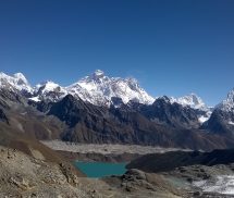
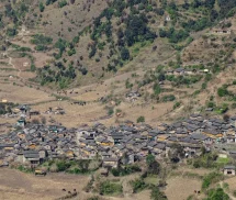
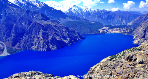
6-7 hours walk, 880m ascent, 90m descent. You follow the Suli Ghad valley, which turns eastward and becomes even steeper and narrower. You climb over a ridge and descends to a wooden bridge, then continue along the ups and downs along the valley floor to the confluence of the Suli Gaad edge of Pungmo Khola. From here the trail to Phoksundo Lake and Shey gompa follows the west bank of the river, to climb through a forest of big cedars to a good camp site and then on to Palam (3710m), a winter settlement used by the people of Ringmo village. The houses are almost buried by sandy soil. The entrance station for Shey Phoksundo National Park is at the south end of the village. After your entrance the park they check here, you may be subjected to a baggage inspection-ostensibly for drugs and stolen art objects. It's a very peculiar formality in this remote locality. You continue on the route, which switchbacks steeply on a sandy trail through open country to an elevation of 3300m, then you start up another steep set of dusty switchbacks to a ridge at 3780m. From the ridge there are distant views of a spectacular 200m -high waterfall, the highest in Nepal. The trail makes a steep descent in birch forests to the upper reaches of the brilliantly clear, rushing waters from Phoksundo Khola, then you climb gently to Ringmo village, with picturesque settlement of flat-roofed stone houses with lots of mud-plastered chortens and mani walls. Just below Ringmo, you cross a bridge and follow a trail north to the ranger station at Phoksundo Lake (3730). You continue to the shores of the lake, near the point where the Phoksundo Khola flows out. There are national park camping grounds on both sides of the river on the south-east shore of the lake. Park rules prohibit, so we choose to camp beyond the lake in other places.
Day 08. - Rest Day in Ringmo
Rest Day:
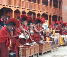
Rest and exploration. A trail leads from the Phoksandu lakeside through juniper trees to the white Pal Sentan Thasoon Chholing gompa, a ramshackle Bon-po gompa overlooking the lake that is said have been built 60 generations ago. There are five other private gompas in various houses of small monastic communities near the lake. There the temples contain dusty Buddhist paintings and statues, but the trappings also reflect the animistic elements of the Bon-po religion, so some of the chapels are reminiscent of an ancient witch's cavern. Donation to the ragtag collection of monks will gain us entrance to the gompas, your staff will be equally fascinated by the strange iconography and practice of the Bon-bo religion.
Day 09. - Ringmo to Chunemba
Ringmo to Chunemba:
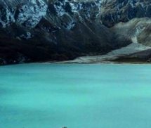
5-6 hours, 570m ascent, 560m descent. From the camp near Ringmo on the southern end of Phoksumdo Lake, the trail contours on a rocky ledge as it skirts the western lip of the lake. In places it is precariously suspended on a gangway of wood, supported on pegs driven into crevices in the rocks. As you cross a stream, look up at the glacier descending from the upper slopes of Kanjeralwa (6612m). Then you climb to a crest at 4060m for a spectacular view of the lake with the snowy peaks of Sonam Kang in the background. The trail makes a step and dusty descent through birches and blue pines to the westernmost edge of the lake at 3630m where the Phoksundo Khola enters. Now the route heads west up long a wide valley. You follow an indistinct trail through thorn bushes and scrub trees, crisscrossing boggy marshes and tributaries of Phoksundo Khola. Camp in a forest of blue pines at Chunemba, an undeveloped national park ground at 3630m
Day 10. - Chuneba to Lar Tsa
Chuneba to Lar Tsa:
4-5hours walk, 570m ascent, 80m descent. Begin the day along the level path that now heads north through a glacial valley. Then cross to the east bank of Phoksundo Khola following the main valley for another hour to Kang Gompa. Steeply climb from Kang Gompa and stay on the grassy ridge long climb up to ridge past a few groves of birch trees. There are spectacular mountain views with Shey Shikar peak (6139m) and Kang Chunne peak (6443m) dominated by skyline to the west. Continue on a crest at 4200m, then the route descends gently on a rocky trail to Lar Tsa, camp is besides the river at 4120m. It's possible to continue walking, but you have now ascended more than 500m in a day and should spend the night at Lar tsa for acclimatization.
Day 11. - Lar Tsa to Mendok
Lar Tsa to Mendok:
Trek to Mendok Ding: 2-3 hours walk, 520m ascent, 130m descent. Cross a new bridge and climb to the top of a scree slope at 4490m, then make your way up to grassy ridge to a crest at 4640m. contour then drop gently into Mendok Ding (flower valley). Again climb alongside a stream to a campsite at 4610m. You are almost certain to see a spot herds of blue sheep on the slopes above the camp.
Day 12. - Mendok to Shey Gompa
Mendok to Shey Gompa:
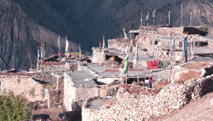
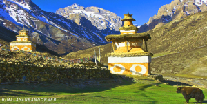
7-8 hours walk, 1040m ascent, 1240m descent. Continue on the route that follows the upper reaches of the Phoksundo Khola, then you turn north towards the peak of Riwo Drugdra (Crystal Mountain). There is a choice of trails here, you follow the more scenic pilgrim route across the Sehu La to the west of Crystal Mountain, making a kora (circumambulation) of this sacred peak. The Dolma trail turns north soon after camp, while the pilgrim trail starts up a steep scree slope on the opposite side of the stream that flows from the north. After a long pull to Sehu La (also known as Mendok Ding La) at 5160m, the trail descends a scree slope to a grassy meadow besides a stream valley and begins a series of long ascents and descends across ridges in and out of side valleys as traverses around Crystal Mountain. After a steep, rough climb to a crest at 5010m and another at 4860m, you begin the descent to the Tar valley. Soon after a grassy slopes side trail leads to Tsakang, a gompa said to be 800 years old that is perched dramatically on the side of a cliff. The final descent is on wide trail to a campsite in a large meadow near a few nomads huts at 4310m, just below Shey gompa.
Day 13. - Shey Gompa rest day
Rest Day:
We rest here and explore. Cross the river on a log bridge, and climb past a big chhorten and a huge field of mani stones to the Shey gompa compound at 4390m. The gompa itself is not large and there are no artifacts or paintings of note inside. Although it was build 800 years ago, the wall paintings are relatively recent, probably in the 1970s. The statues on the altar of Guru Rimpoche, Sakyamuni and Milarepa. The gompa also houses an ancient Tibetan scroll that describes the myth of Crystal Mountain and Shey gompa. According to the inscription, there is a holy lake in a crater among the mountains that surrounds Shey. When a pilgrim makes nine circumambulations of this lake the water turns into milk. A sip of this milk, and the pilgrim can see Mt Kailash in the distance. So for those who don't need the day for rest, you will go and try to find this lake.
Day 14. - Shey Gompa to Namgung
Shey Gompa to Namgung:
6-7 hours walk, 1029m ascent, 900m descent. We trek east from Shey gompa and across the 5010m Shey La. Here you turn north and descend before climbing again to Namgung (4430m). Camp.
Day 15. - Namgung to Karang
Namgung to Karang:
5-6 hours walk, 150m ascent, 530m descent. We cross high above the Namgung Ko La to Karang (4050m). It's also possible to descend to Saldang on the banks of the river, but this village holds little of interest. Camp there.
Day 16. - Karang to Mugaon
Karang to Mugaon:
6-7 hours walk, 490m ascent, 550m descent. Descend to Torak Sumdo (3670m) as confluence of the Namgung and Polang kholas, and cross to the northern bank, then climb to Yanger gompa at 3750m and trek along the valley on the river side. We camp alongside the stream at about 4100m before Mugaon.
Day 17. - Mugaon to Shimen
Mugaon to Shimen:
7-8 hours walk 1040 m ascent, 890m descent. Continue up to the valley to Mugaon and climb towards Mushi La at 5030m. Then descend towards Shimen village; end of the day at a good camp site as over the pastures above the village at 4010m.
Day 18. - Shimen to Tinje
Shimen to Tinje:
7-8 hours walk 550m ascent, 170m descent. Drop down to Shimen village at 3870m and make a long trek up river through Pha (4090m) to Tinje (4150m), where we put on the tent.
Day 19, - Tinje to Rakpa
Tinje to Rakpa:
7-8 hours walk 550m ascent, 170m descent. Your trek passes to runway of mysterious Tinje airport on the trail junction at 4130m, where a high route leads to Tarap, as another continues southward to the camp site on the banks of the river at Rakpa (4530m)
Day 20. - Rakpa to Chharka
Rakpa to Chhartka:
7-8 hours, 490m ascent, 900m descent. Begin your day with a long climb to the Chharka La (4920m) continuing on the trail, descending along the side of the valley, then make a big drop into a side valley at 4290m. Then make a long traverse down to the picturesque village of Chharka on the banks of Barbung Kola at 4120m. Camp.
Day 21. - Chharka to Norbulung
Chharka to Norbulung:
6-7 hours walk 820m ascent, 190m descent. Another climb to a cross at 4380m begins this day, then descend again to a river, then follow the right fork southward and climb into out of side valleys on a rough trail. The narrow valley then emerges into a big meadow and we climb to the campsite of Norbulung (4750m).
Day 22. - Norbulung to Sangda phedi
Norbulung to Sangda phedi:
7-8 hours walk, 790m ascent, 440m descent. Today you climb to the yak pasture at Molum Sumna (4860m) and crest at 5130m; then make a long traverse across meadows to the foot of the Sangda La. Then a long final steep climbs to the pass at 5460m. Down to your camp site by a stream at 5100m.
Day 23. - Sangda phehi to Sangda
Sangda phedi to Sangda:
7-8 hours walk, 460m ascent, 1860m descent. Climb to a lower Sangda La at 4990m and descend through loose shale towards the village of Sangda Ghunsa 4190m. Drop to crossing Chalung Khola, 3750m, and then climb steeply bank up the opposite. A long high traverse leads to a cairn at 4090m; then come to a set of steep switchbacks descends to a stream at 3580m. And another climb to the compact settlement of Sangda, where a long day ends at 3700m.
Day 24. - Sangda to Dhagarjun
Sangda to Dhagarjun:
7-8 hours walk, 970m ascent, 1380m descent. Climb the hill behind Sangda and spent most of the day making a high traverse, crossing nine ridges to a final crest at 4280m. Then descend into the Kali Gandaki valley crossing by the pass under high cliffs, and descend to the large village of Dhagarjun (3290m).
Day 25. - Dhagarjun to Jomsom
Dhagarjun to Jomsom:
Trek to Jomsom, then fly to Pokhara : 3hours walk, 870m ascent, 690m. The descent climbs down to a ridge at 3360m and makes a final descent on a challenging trail of loose rocks to Jomsom at 2670m. If possible we take the flight this day; if not, we spend a night in Jomsom and catch the flight early morning from Jomsom to Pokhara - a fantastic way to round off the trek, flying right along the Kali Gandaki Gorge between the Annapurna and Dhaulagiri ranges. In Pokhara you check into the Hotel ; clean dust of the last three weeks washed off!
Day 26. - Jomsom to Pokhara and Kathmandu flights
Jomsom to Pokhara and to Kathmandu flights:
Flights Jomsom /Pokhara /Kathmandu : we catch early morning the flight to Pokhara and from there and connecting flight back to Kathmandu.
Day 27. - Free Day in Kathmandu
Kathmandu: free day on your own.
This day is free and you can use it for your shopping. In the evening we will drive you to a farewell dinner with cultural dance.
Day 28. - Final departure
Final Departure to international airport by our private vehicles.
Cost Service includes -
# Airport Pick up & Drop Transportation by private vehicle
# Twin sharing accommodation at Kathmandu and Nepalgunj in hotels with breakfast
# Kathmandu/Nepalgunj / private transportation vehicules
# Nepalgunj/Jumla and Jomsom Pokhara Kathmandu flight ticket per member & Nepali staff
# Accommodation in tent during trek and staffs trekking; equipment; bus fare fromJomsom to Kathmandu
# Meals (Breakfast, lunch, dinner) during the trekking
# All cost for the staff # # Eco trained & Government licensed holder guide and required Porters while trekking
# Accommodation, meals, salary, equipment, transportation & Insurance for staffs
# Experienced cook, Assistance-helper and kitchen crew.
# Tents, mattress, cooking utensils and camping equipment for the trekking period,
# All government taxes, Dolpo especial royalty and Annapurna conservation entry fee; and TIMS
# Farewell dinner in Kathmandu
Cost Service excludes. -
# International Airfare
# Nepal Visa fee (US$50 per person for 30 days)
# Airport Departure taxes/Excess baggage charges.
# Lunch/Dinner in Kathmandu & Nepalgunj
# Lower Dolpo Restricted Permit
- First 7 days US$ 90
- After 7 days US$ 15/ per Day
# Medical evacuation in case of emergency.
# Personal gears & clothing (available on hire)
# Expenses incurred due to mishaps, landslide, strikes, political unrest etc. In such case extra will be charged.
# Client's insurance, Items of personal nature Soft/hard drinks; etc
# Tips for the staff.
Upcoming Trip Departure
Guaranteed - Trip is Guaranteed to run
Available - Trip is available to run if minimum group size is filled
Limited - Only few space available
| Trip Start Date | Trip End Date | Price | Avability | Book |
|---|
Laurence , Dolpo Trek
It was really nice trip to Dolpo with my guide Santosh Gurung. thank you