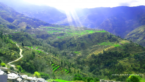
Gurja Khani trekking route is a footpath where you can see the panoramic views of Dhaulagiri and Annapurna range. This is truly a hidden valley in Dhaulagiri and Gurja himal region. While the Gurja Khani trekking trail is less frequented tourists, this trekking trail passes through the wild and beautiful Dhaulagiri valley. The village sits on a sunny shelf under the snowcap of the Dhaulagiri range. The hidden village is consequently an undiscovered gem. So it can experience well-beaten routes with meeting local people and helping those innocent villagers.
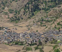
Gurja Khani Trekking trail is a highlight a view of the 7th highest mountain, Dhaulagiri 8172m, Gurja Himal 7193m and Churen Himal 7371m. Inhabited by the Chhantyal villagers, most of the people are Vishwakarma and farmers and herdsmen. They practice their traditional blacksmith skills. As for their attire, men wear thick wool jackets woven by women, which are waterproof. In the summer, they take their flocks to an altitude of 5,000 meters. In winter time as snow falls on villages, they leave thire temporary settlements in the lower valley of Dhaulagiri zone. The village is a maze of narrow streets, the houses are so tight that one roof slate touches another. The older houses feature intricately carved wooden windows for which the Gurja miners are famous.

Gurja Trekking trail is one of the funniest places to hike in Gurja Himal also where you can do extracurricular activities for a few days. In the morning you can walk to Gurja Himal View Point. A steep climb leads to the old apple orchard at the foot of Gurja Himal. The trail follows the rhododendron clusters before reaching the pleasant grass and shepherds huts. After lunch you can visit the old copper mine, see honey hunting area and bird watching. On the Gurja Himal trekking route one can watch a special local cultural dance performed by a mother group or youth club. Many families live at home in the Gurja village area, with their own hospitality.

Furthermore, if you need help to manage plans for this region trek, kindly keep in touch with Himalayanrandoner, we will fully support you.
day 01: arrive Kathmandu - elevation: 1350m
Arrival at Kathmandu International airport, we pick up you by our private vehicle to hotel, it takes 30m, and check in, Overnight Hotel, with BB,
Day 02: Kathmandu-Pokhara - Elevation: 850m,
Drive to Pokhara 200km. We leave around 7am for Pokahra, According to the group, we provide a tourist bus or private vehicle. depend on group, It takes 5/6hrs, Pokhara is the second city of Nepal and a clean city. You can watch Annapurna range when you reach Pokhara, and walk along Phewa Lake., Overnight Hotel with BB,
Day 03: Pokhara-Darbang - Elevation: 1099m, 6/7hrs drive,
Drive from Pokhara to Darbang village by local or private bus, (depending on the group) after Beni bazar drive on bumping road, about 3hrs from Beni bazar. Overnight Guest house,
Day 04: Darbang-Rum Village - Elevation: 1950m, 5hrs walk
Darbang to Rum Gaun: we start trekking from Darbang after breakfast, leaving around 7-8am, to the south and north through Niskot or directly. We cross the river and walk to Rum gaun in forest. It is a beautiful Magar and biswakarma village. Views of Dhaulagiri along the way. Overnight in local guest house
Day 05: Ruma Gaun-Taman village, - Elevation: 2050m, 6hrs walk,
Trek to Taman village, 400m descend to the river, crossing a bridge and climbing to the Sole pass. Lunch break before Bunger danda, nice view of the Dhaulagiri and Annapurna ranges. We walk on the road to Taman, 2600m, inside the forest, through a village of Chhandal, and reach Taman. Overnight in local guest house.
Day 06: Taman-Bongakhani - Elevation: 2000m, 4hrs walk,
Trek to descend among fields of millet and maize, on the edge of the small river to Bongadobhan (1300m). Then we turn to the right to Bongakhani. This day no views just have to between many hills and edge of the rivers, only local typical houses, fields and local life. Overnight in local guest house,
Day 07: Bungadobhan-Lamachour or Gurjaghat, - Elevation: 2300m, 3300m, 3000m, 2hrs/8hrs walk,
trek to Lamachour (2000m), last village or Gurjaghat through Gurja pass (3300m) Steep climb inside forest to the pass, 3/4hrs more, and descent to Gurjakhat village, 3hrs, Gurjaghat is the last village, cross on the way to Dhorpatan and to Gurjakhani village. there permanent settle is only in Summer, left in autumn. Sometimes we can't find people so have to pitch the tent. overnight in local guest house
Day 08: Gurjaghat-Rupachaur, - Elevation: 3300m, 4hrs, walk,
Gurjaghat to Rupachaur, one solution is to camp in Rupachaur pass. This day we walk inside the pine, sup-pine and juniper forest. All day long we have to cross a river many times to reach Rupachaur. Sometimes you can see wild animals if we are lucky, Overnight Camp in tent,
Day 09: Rupachaur-Gurjakhani village - Pass 3850m: 2650m, 7hrs walk,
Rupachaur to Gurjakhani, is a spectacular day. It is little hard to pass during the spring season as there is lots of snow rest. Be careful with altitude. We prepare a backpack lunch. Beautiful views from pass, Views of Gurja Himal can be enjoyed on the way up and down and land at Gurja. The trail leads to a flat grassland. There is a stream of water on the right and an empty building, above which the full face of Gurja Himal partially visible. Gurjakhani village is also visible from the left and about 15 minutes from here one can reach the level footpath. Near the village, overnight in local Guest house
Day 10: Rest Day, Gurjakhani, - Elevation: 2650m, visit, exploring local house,
GurjkKhani village is a pleasant place to spend a few nights. The villagers have built a community bathhouse with hot showers heated by green hydropower. Things to do include pony riding walks (flora & fauna temples, village crafts, mining tunnels), and day-hike to the foot of Gurja Himal, and exploring the village: local houses, local activities. Overnight in the same guest house
Day 11: Gurjakhani-Deurali pass, Lumsum, - Elevation: 3350m, 2190m, 6/7hrs walk,
trek to Deurali pass along the trail, crossing the small rivers, which leads to the charming marvelous farmlands, and the dense fores. Lunch after pass with local people, but sometimes we can't find people in house as they are in their field to farm, so it is better to manage backpack lunch, and descend to Lumsum small village. overnight in local house
Day 12: Lumsum trek to Muna pokhara, - Elevation: 850m 1hrs walk and catch the bus to pokhara,
We have a little walk and catch the private vehicle or local bus to Pokhara. It takes a 7/8hrs drive over the bumping road to Beni then a good road to Pokhara. Overnight in the same Hotel with BB
Day 13: Pokhara-Kathmandu, - Elevation:1350, 6/7hrs drive,
around 7:30 am from tourist bus station we catch a tourist bus, Pokhara to Kathmandu. Lunch break on the half way to kathmandu, and arrival at Kathmandu. Overnight same hotel with BB
Day 14: Rest In Kathmandu, - Visit and buy souvenir,
Visit Pashupatinath, Boudhanath stupa, Swayambhunath stupa of Kathmandu, Overnight same hotel with BB
Day 15: Depart to international airport, - Departure by private vehicle,
we depart you by our private vehicle as a group, according to your flight. We have to depart before 3/4 hrs, and wish you to have you a happy journey
Upcoming Trip Departure
Guaranteed - Trip is Guaranteed to run
Available - Trip is available to run if minimum group size is filled
Limited - Only few space available
| Trip Start Date | Trip End Date | Price | Avability | Book |
|---|